پرونده:Old Greenland 1747.jpg

Page contents not supported in other languages.
از ویکی‌پدیا، دانشنامهٔ آزاد

پروندهٔ اصلی(۲٬۰۴۸ × ۱٬۳۰۷ پیکسل، اندازهٔ پرونده: ۲٫۲۳ مگابایت، نوع MIME پرونده: image/jpeg)

خلاصه

توضیح
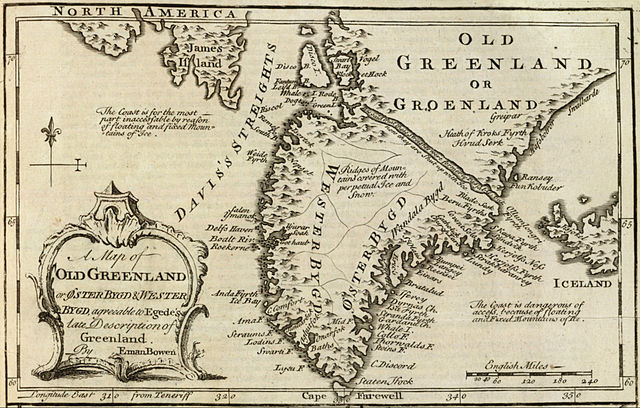
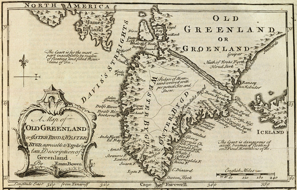
English: Cropped and rotated from the original.


Original description from the David Rumsey Historical Map Collection:

Author:
Bowen, Emanuel
Date:
1747
Short Title:
Old Greenland.
Publisher:
William Innys [et al.]
London
Type:
Atlas Map
Obj Height cm:
33
Obj Width cm:
23
Scale 1:
9,850,000
Note:
Engraved map. Includes geographic notes and ornamental cartouche. Relief shown pictorially. Ancillary maps [here omitted]: A map of the islands of Ferro or Farro according to Jacobson Debes -- A draught of the Whirlpool, on the south east of Sumbo Rocks wth. the soundings -- An improved map of Iceland. Prime meridian: Teneriffe.
Reference:
P-Maps, p. 303 (1752 ed.); NMM p.356; M&B p 166.
Country:
Greenland; Iceland [here omitted]
Full Title:
A map of old Greenland or Oster Bygd & Wester Bygd, agreeable to Egede's late description of Greenland. By Eman. Bowen. (London: Printed for William Innys, Richard Ware, Aaron Ward, J. and P. Knapton, John Clarke, T. Longman and T. Shewell, Thomas Osborne, Henry Whitridge ... M.DCC.XLVII)
List No:
3733.070
Page No:
No. 71
Series No:
73
Publication Author:
Bowen, Emanuel
Pub Date:
1747
Pub Title:
A complete system of geography. Being a description of all the countries, islands, cities, chief towns, harbours, lakes, and rivers, mountains, mines, &c. of the known world ... In two volumes. The whole illustrated with seventy maps, by Emanuel Bowen, Geographer to His Majesty, being all new-drawn and ingraved according to the latest discoveries and surveys; making, of themselves, a complete atlas, for the sse of gentlemen, merchants, mariners, and others, who delight in history and geography ... Vol. 1. London: Printed for William Innys, Richard Ware, Aaron Ward, J. and P. Knapton, John Clarke, T. Longman and T. Shewell, Thomas Osborne, Henry Whitridge ... M.DCC.XLVII.
Pub Reference:
cf P614 (1752 edition of A Complete Atlas...); NMM p.356; M&B p 166.
Pub Note:
"Preserving all that is useful in the Fourth and Last edition of the Complete Geographer, publish'd under the name of Herman Moll, &c."
Pub List No:
3733.000
Pub Type:
Geography Book
Pub Maps:
70
Pub Height cm:
43
Pub Width cm:
28
Image No:
3733070
Institution:

Rumsey Collection
تاریخ
منبع David Rumsey Collection
پدیدآور Emanuel Bowen (c. 1694–1767)

اجازه‌نامه

این اثر هنری دوبعدی که در این نگاره دیده می‌شود بخاطر تاریخ درگذشت پدیدآورنده آن یا تاریخ انتشارش هم‌اکنون در سراسر جهان در مالکیت عمومی قرار دارد و استفاده از آن آزاد است.
Public domain

این اثر در کشورهایی و مناطقی که مدت زمان حق تکثیر، عمر پدیدآورنده بعلاوه 100 سال یا کمتر بعد از مرگ او است، در مالکیت عمومی قرار دارد.


You must also include a United States public domain tag to indicate why this work is in the public domain in the United States.
بنابراین تکثیر آن در ایالات متحده آمریکا، آلمان و بسیاری کشورهای دیگر آزاد است.

تاریخچهٔ پرونده

روی تاریخ/زمان‌ها کلیک کنید تا نسخهٔ مربوط به آن هنگام را ببینید.

تاریخ/زمانبندانگشتیابعادکاربرتوضیح
کنونی‏۱۰ مهٔ ۲۰۱۲، ساعت ۱۵:۲۱تصویر بندانگشتی از نسخهٔ مورخ ‏۱۰ مهٔ ۲۰۱۲، ساعت ۱۵:۲۱۲٬۰۴۸ در ۱٬۳۰۷ (۲٫۲۳ مگابایت)LlywelynII

صفحهٔ زیر از این تصویر استفاده می‌کند:

کاربرد سراسری پرونده

ویکی‌های دیگر زیر از این پرونده استفاده می‌کنند: