
پرونده:Myanmar civil war.svg

پروندهٔ اصلی (پروندهٔ اسویجی، با ابعاد ۱٬۲۲۸ × ۲٬۰۰۳ پیکسل، اندازهٔ پرونده: ۱٫۳ مگابایت)
این پرونده در ویکیانبار موجود است. محتویات صفحهٔ توصیف آن در زیر نمایش داده میشود. |

|
This file may be updated to reflect new information. If you wish to use a specific version of the file without new updates being mirrored, please upload the required version as a separate file. |
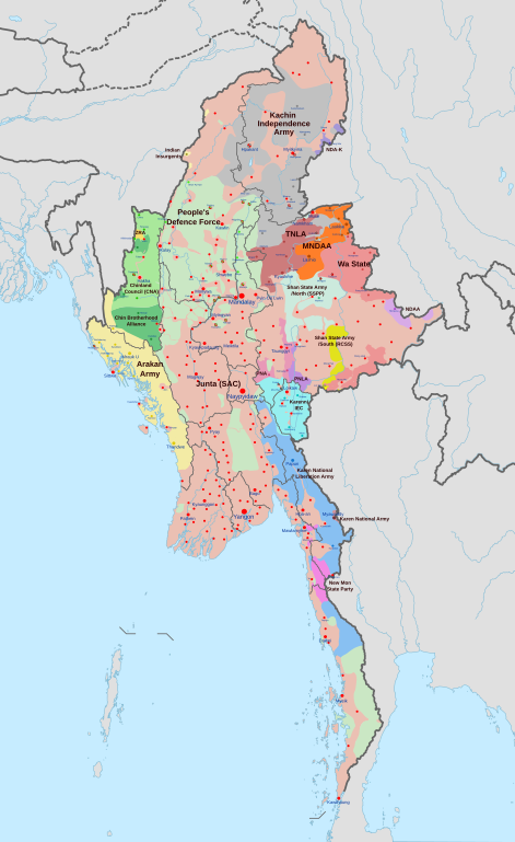
خلاصه
| توضیح |
English: A map of the Myanmar civil war (2021–present)
|
| تاریخ | |
| منبع | اثر شخصی derivate of Myanmar adm location map.svg by NordNordWest. Citing @ThomasVLinge |
| پدیدآور | Ecrusized |
| دیگر نسخهها |
|

This file is translated using SVG For most Wikipedia projects, you can embed the file normally (without a To translate the text into your language, you can use the SVG Translate tool. Alternatively, you can download the file to your computer, add your translations using whatever software you're familiar with, and re-upload it with the same name. You will find help in Graphics Lab if you're not sure how to do this. |
اجازهنامه
| این پرونده تحت CC0 1.0 Universal Public Domain Dedication کریتیو کامنز قابل دسترسی است. | |
| کسی که اثری را با این سند همراه کرده است، با چشمپوشی از تمام حقوق خود نسبت به اثر در جهان تحت قانون کپیرایت و همهٔ حقوق قانونی مرتبط یا همسایهای که او در اثر داشته است، تا حد مجاز در قانون، آن را به مالکیت عمومی اهدا کرده است. شما میتوانید بدون گرفتن اجازه این اثر را تکثیر کنید، تغییر دهید، منتشر کنید یا دوباره ایجاد کنید، حتی اگر مقاصد تجاری داشته باشید.
|
تاریخچهٔ پرونده
روی تاریخ/زمانها کلیک کنید تا نسخهٔ مربوط به آن هنگام را ببینید.
| تاریخ/زمان | بندانگشتی | ابعاد | کاربر | توضیح | |
|---|---|---|---|---|---|
| کنونی | ۳۰ آوریل ۲۰۲۴، ساعت ۱۰:۳۲ | | ۱٬۲۲۸ در ۲٬۰۰۳ (۱٫۳ مگابایت) | MrBLOCKiron | Continuation of yesterdays edit, check april 29 discussion. |
| ۲۹ آوریل ۲۰۲۴، ساعت ۱۶:۴۵ |  | ۱٬۲۲۸ در ۲٬۰۰۳ (۱٫۳ مگابایت) | MrBLOCKiron | Update, check talk page for notes and sources | |
| ۱۷ آوریل ۲۰۲۴، ساعت ۱۸:۴۶ |  | ۱٬۲۲۸ در ۲٬۰۰۳ (۱٫۲۹ مگابایت) | EmeraldRange | Updating Myawaddy area to reflect territory taken - Shwekoko to the north and Thinganyinaung to the west as per Talk on en:Myanmar civil war (2021-present) | |
| ۱۲ آوریل ۲۰۲۴، ساعت ۰۳:۰۱ |  | ۱٬۲۲۸ در ۲٬۰۰۳ (۱٫۳ مگابایت) | PequodOnStationAtLZ | updated to reflect rebel capture of myawaddy | |
| ۴ آوریل ۲۰۲۴، ساعت ۲۰:۵۲ |  | ۱٬۲۲۸ در ۲٬۰۰۳ (۱٫۳ مگابایت) | EmeraldRange | Updated based on Timelines , sources and new map from van Linge; see File Talk/Discusion for sources | |
| ۲۳ مارس ۲۰۲۴، ساعت ۱۵:۳۵ |  | ۱٬۲۲۸ در ۲٬۰۰۳ (۱٫۲۹ مگابایت) | TheWasalpha | Capture of Rathedaung last week by AA, removed a misplaced dot in Bangladesh | |
| ۱۷ مارس ۲۰۲۴، ساعت ۱۶:۴۷ |  | ۱٬۲۲۸ در ۲٬۰۰۳ (۱٫۲۹ مگابایت) | EmeraldRange | Updated with other items to March 17, see File Talk/Discussion | |
| ۱۶ مارس ۲۰۲۴، ساعت ۰۶:۳۲ |  | ۱٬۲۲۸ در ۲٬۰۰۳ (۱٫۲۷ مگابایت) | Hoben7599 | See discussion for source links | |
| ۲۱ فوریهٔ ۲۰۲۴، ساعت ۱۵:۱۲ |  | ۱٬۲۲۸ در ۲٬۰۰۳ (۱٫۲۷ مگابایت) | EmeraldRange | Updated to include Myebon capture, Mabein capture and AA territory updates based on source from Talk:Myanmar civil war. (See discussion for source links) | |
| ۱۶ فوریهٔ ۲۰۲۴، ساعت ۰۳:۲۵ |  | ۱٬۲۲۸ در ۲٬۰۰۳ (۱٫۲۷ مگابایت) | EmeraldRange | fixed wrong layering for Karenni |
کاربرد پرونده
صفحههای زیر از این تصویر استفاده میکنند:
کاربرد سراسری پرونده
ویکیهای دیگر زیر از این پرونده استفاده میکنند:
- کاربرد در ar.wikipedia.org
- کاربرد در en.wikipedia.org
- کاربرد در es.wikipedia.org
- کاربرد در et.wikipedia.org
- کاربرد در fr.wikipedia.org
- کاربرد در hu.wikipedia.org
- کاربرد در it.wikipedia.org
- کاربرد در ja.wikipedia.org
- کاربرد در ko.wikipedia.org
- کاربرد در ms.wikipedia.org
- کاربرد در my.wikipedia.org
- کاربرد در pt.wikipedia.org
- کاربرد در ru.wikipedia.org
- کاربرد در th.wikipedia.org
- کاربرد در uk.wikipedia.org
- کاربرد در zh.wikipedia.org