
پرونده:506-Castile 1210.png
تفکیکپذیری بالاتری در دسترس نیست.
506-Castile_1210.png (۴۷۴ × ۵۰۶ پیکسل، اندازهٔ پرونده: ۱۳۸ کیلوبایت، نوع MIME پرونده: image/png)
این پرونده در ویکیانبار موجود است. محتویات صفحهٔ توصیف آن در زیر نمایش داده میشود. |
خلاصه
| توضیح |
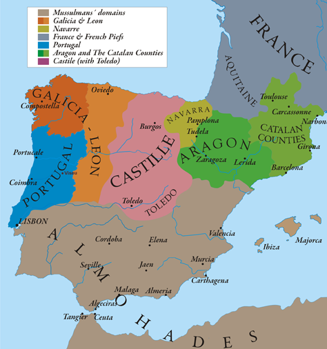
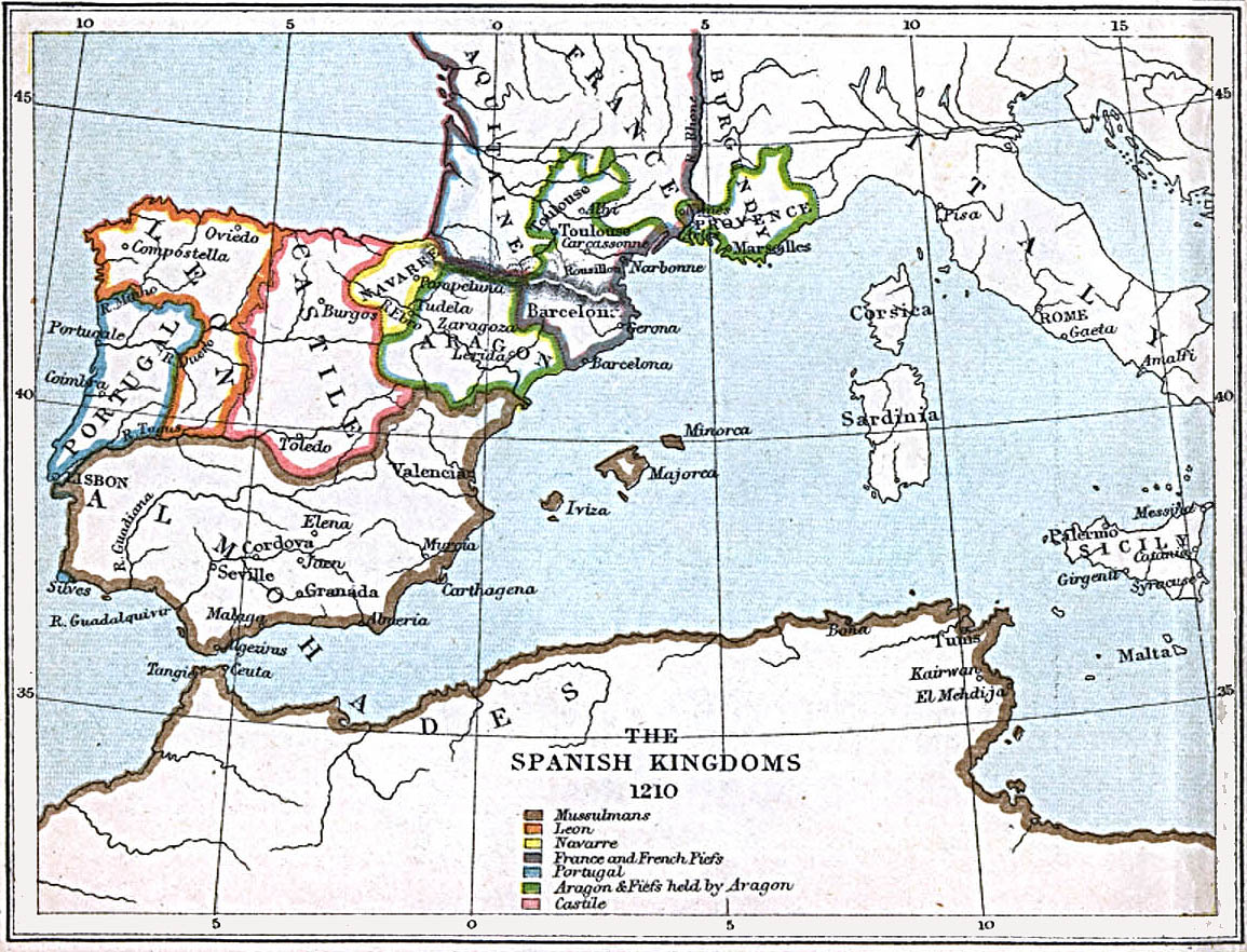
English: This map show Al-Andalus (Almohades) and European Christian kingdoms. 12th-13th centuries. It´s made from "The Historical Atlas by William R. Shepherd, 1926". |
| تاریخ | |
| منبع | اثر شخصی |
| پدیدآور | Alexandre Vigo |
| اجازهنامه (استفادهٔ مجدد از این پرونده) |
Texas University |
| دیگر نسخهها | http://www.lib.utexas.edu/maps/historical/spanish_kingdoms_1210.jpg |

|
این historical map نگاره میبایست با استفاده از گرافیک برداری اسویجی فایل بازسازی شوند. این چند مزیت دارد؛ Commons:Media for cleanup را برای اطلاعات بیشتر ببینید. اگر حالت برداری آن در حال حاضر موجود است، لطفاً آن را بار کنید. پس از بارکردن یک اسویجی، این الگو را با {{vector version available|new image name.svg}} جایگزین کنید.
|
اجازهنامه
من، صاحب حقوق قانونی این اثر، به این وسیله این اثر را تحث اجازهنامههای ذیل منتشر میکنم:

|
اجازهٔ کپی، پخش و/یا تغییر این سند تحت شرایط مجوز مستندات آزاد گنو، نسخهٔ ۱٫۲ یا هر نسخهٔ بعدتری که توسط بنیاد نرمافزار آزاد منتشر شده؛ بدون بخشهای ناوردا (نامتغیر)، متون روی جلد، و متون پشت جلد، اعطا میشود. یک کپی از مجوز در بخشی تحت عنوان مجوز مستندات آزاد گنو ضمیمه شده است. |
این پرونده با اجازهنامهٔ کریتیو کامانز Attribution-Share Alike 3.0 سازگار نشده منتشر شده است.
- شما اجازه دارید:
- برای به اشتراک گذاشتن – برای کپی، توزیع و انتقال اثر
- تلفیق کردن – برای انطباق اثر
- تحت شرایط زیر:
- انتساب – شما باید اعتبار مربوطه را به دست آورید، پیوندی به مجوز ارائه دهید و نشان دهید که آیا تغییرات ایجاد شدهاند یا خیر. شما ممکن است این کار را به هر روش منطقی انجام دهید، اما نه به هر شیوهای که پیشنهاد میکند که مجوزدهنده از شما یا استفادهتان حمایت کند.
- انتشار مشابه – اگر این اثر را تلفیق یا تبدیل میکنید، یا بر پایه آن اثری دیگر خلق میکنید، میبایست مشارکتهای خود را تحت مجوز یکسان یا مشابه با ا اصل آن توزیع کنید.
میتوانید مجوز دلخواه خود را برگزینید.
تاریخچهٔ پرونده
روی تاریخ/زمانها کلیک کنید تا نسخهٔ مربوط به آن هنگام را ببینید.
| تاریخ/زمان | بندانگشتی | ابعاد | کاربر | توضیح | |
|---|---|---|---|---|---|
| کنونی | ۱۲ مهٔ ۲۰۱۰، ساعت ۲۰:۵۸ | | ۴۷۴ در ۵۰۶ (۱۳۸ کیلوبایت) | Alexandre Vigo~commonswiki | {{Information |Description={{en|1=This map show Al-Andalus (Almohades) and European Christian kingdoms. 12th-13th centuries. It´s made from "The Historical Atlas by William R. Shepherd, 1926".}} |Source={{own}} |Author=[[User:Alexandre Vigo|Alexandre Vig |
کاربرد پرونده
صفحههای زیر از این تصویر استفاده میکنند:
کاربرد سراسری پرونده
ویکیهای دیگر زیر از این پرونده استفاده میکنند:
- کاربرد در ar.wikipedia.org
- کاربرد در arz.wikipedia.org
- کاربرد در ast.wikipedia.org
- کاربرد در azb.wikipedia.org
- کاربرد در az.wikipedia.org
- کاربرد در ba.wikipedia.org
- کاربرد در be.wikipedia.org
- کاربرد در br.wikipedia.org
- کاربرد در ca.wikipedia.org
- کاربرد در cs.wikipedia.org
- کاربرد در cy.wikipedia.org
- کاربرد در de.wikipedia.org
- کاربرد در en.wikipedia.org
- کاربرد در en.wikibooks.org
- کاربرد در es.wikipedia.org
- کاربرد در et.wikipedia.org
- کاربرد در fr.wikipedia.org
- Aragon
- Conquête almohade d'al-Andalus
- Royaume de Castille
- Espagnes médiévales
- Histoire d'al-Andalus
- Géographie d'al-Andalus
- Formation territoriale de l'Espagne
- Histoire de l'Occitanie
- Histoire des grandes puissances
- Liste des commanderies templières en Castille-et-León
- Liste des commanderies templières en Galice
نمایش استفادههای سراسری از این پرونده.