
پرونده:1724 De L'Isle Map of Persia (Iran, Iraq, Afghanistan) - Geographicus - Persia-delisle-1724.jpg

پروندهٔ اصلی (۴٬۵۰۰ × ۳٬۵۵۳ پیکسل، اندازهٔ پرونده: ۵٫۵۸ مگابایت، نوع MIME پرونده: image/jpeg)
این پرونده در ویکیانبار موجود است. محتویات صفحهٔ توصیف آن در زیر نمایش داده میشود. |
| این یک نگاره برگزیده است، بدین معنی که اعضای جامعه آن را بهعنوان یکی از نگارههای خوب در ویکیپدیای فارسی شناختهاند. اگر شما نگارهای متفاوت با کیفیت مشابه دارید، مطمئن شوید که آن را با برچسب مجوز آزاد بارگذاری میکنید، به مقالهٔ مرتبط میافزایید و آن را نامزد میکنید. |
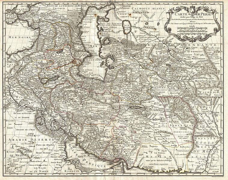
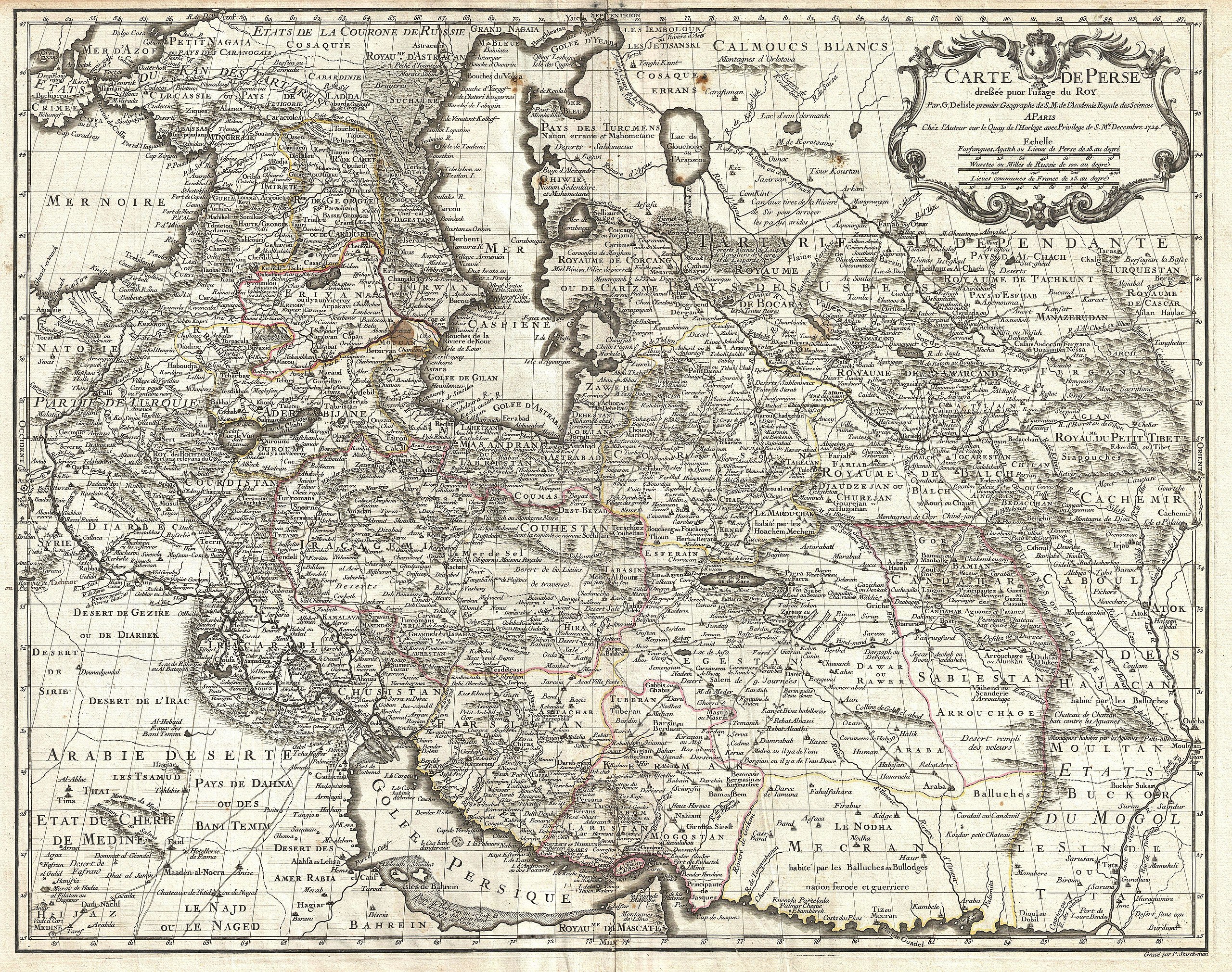
| Carte de Perse, dressee pour l'usage du Roy. Par G. Delisle premier Geographe de S.M. de l'Academie Royale des Sciences. | ||||||
|---|---|---|---|---|---|---|
| هنرمند |
Guillaume Delisle |
|||||
| عنوان |
Carte de Perse, dressee pour l'usage du Roy. Par G. Delisle premier Geographe de S.M. de l'Academie Royale des Sciences. |
|||||
| توضیح |
English: A fine first edition example of Guillaume De L’Isle’s important 1724 map of Persia. Covers from the Crimea and the Sea of Azov south to the Persian Gulf and the Straight of Ormuz and east as far as Kashmir (Cachmir) and Kabul (Caboul). This map includes modern day Iran, Iraq, Afghanistan, Kuwait, Uzbekistan, Turkmenistan, Tajikistan, Georgia, Armenia, and Azerbaijan, with adjacent parts of Russia, Pakistan, Turkey, Ukraine, and Kazakhstan, and Arabia. Cartographically De L’Isle’s mapping of Persia marks a significant advance in European cartographic knowledge of the region. This map benefits considerably from Russian cartographic surveys and other sources no doubt smuggled to Guillaume De L’Isle by his brother Nicholas de L’Isle, who held a cartographic position with the Russian Academy of Sciences. The extent to which Russian data influenced this map is nowhere more evident than in De L’Isle’s remarkable rendering of the Caspian Sea – one of the first accurate maps of the great lake to follow Van Verden’s historic survey of 1721. Russian cartographic information is also apparent with regard to place names, such as the Russian name for the Aral Sea (Glouchoiye). It is equally likely that De L’Isle drew on Russian sources for his mapping of the Silk Route centers of Bukhara, Samarkand, and Ferghana, which were known stopping points for Russian trade envoys to China. For the remainder of Persia De L’Isle most likely updated Persian and Arabic cartographic information with reports from Georgian and Armenian traders and mercenaries active throughout Persia. It may be through these sources that De L’Isle was able to add considerable geographic information regarding trade routes and place names in central Persia. These include such significant advances as the identification of Terheran (Tiheran), the current capital of Iran, which is notable absent it earlier European maps of Persia. This map was drawn by Guillaume De L’Isle and engraved by P. Starckman. It issued independently as well as included in a number of composite atlases including De L’Isle’s 1731 Atlas de Geographie . A number of reissues by Buache, Covens & Mortier, and others followed. |
|||||
| تاریخ | ۱۷۲۴ (undated) | |||||
| ابعاد | بلندی: ۲۰٫۰ اینچ (۵۰٫۸ سانتیمتر)؛ عرض: ۲۵٫۰ اینچ (۶۳٫۵ سانتیمتر) | |||||
| آیدی |
Geographicus link: Persia-delisle-1724 |
|||||
| منبع/عکاس |
De L'Isle, G., Atlas de Geographie, c. 1730.
|
|||||
| اجازهنامه (استفادهٔ مجدد از این پرونده) |
|
|||||
| دیگر نسخهها |
|
|||||
_-_Geographicus_-_Persia-delisle-1724_(Talish_region).jpg)
_-_Geographicus_-_Persia-delisle-1724_(cropped).jpg)
_-_Geographicus_-_Persia-delisle-1724._A.jpg)
_-_Geographicus_-_Persia-delisle-1724._B.jpg)
_-_Geographicus_-_Persia-delisle-1724._C.jpg)
_-_Geographicus_-_Persia-delisle-1724._D.jpg)
_-_Geographicus_-_Persia-delisle-1724._E.jpg)
_-_Geographicus_-_Persia-delisle-1724._F.jpg)
_-_Geographicus_-_Persia-delisle-1724._G.jpg)
_-_Geographicus_-_Persia-delisle-1724._H.jpg)
_-_Geographicus_-_Persia-delisle-1724._I.jpg)
_-_Geographicus_-_Persia-delisle-1724.jpg?uselang=fa)
_-_Geographicus_-_Persia-delisle-1724.jpg)
|
_-_Geographicus_-_Persia-delisle-1724.jpg)
تاریخچهٔ پرونده
روی تاریخ/زمانها کلیک کنید تا نسخهٔ مربوط به آن هنگام را ببینید.
| تاریخ/زمان | بندانگشتی | ابعاد | کاربر | توضیح | |
|---|---|---|---|---|---|
| کنونی | ۲۵ مارس ۲۰۱۱، ساعت ۰۳:۵۳ | | ۴٬۵۰۰ در ۳٬۵۵۳ (۵٫۵۸ مگابایت) | BotMultichillT | {{subst:User:Multichill/Geographicus |link=http://www.geographicus.com/P/AntiqueMap/Persia-delisle-1724 |product_name=1724 De L'Isle Map of Persia (Iran, Iraq, Afghanistan) |map_title=Carte de Perse, dressee pour l'usage du Roy. Par G. Delisle premier Geo |
کاربرد پرونده
صفحههای زیر از این تصویر استفاده میکنند:
- نقشه ایران در اواخر دوره صفویه
- بحث کاربر:Alborzagros/بایگانی ۲۰
- ویکیپدیا:نگاره روز/اوت ۲۰۱۴
- ویکیپدیا:نگارههای برگزیده/نقشه
- ویکیپدیا:گزیدن نگاره برگزیده/1724 De L'Isle Map of Persia (Iran, Iraq, Afghanistan) - Geographicus - Persia-delisle-1724.jpg
- ویکیپدیا:گزیدن نگاره برگزیده/مارس-۲۰۱۴
- الگو:نر/2014-08-02
- الگو:نر محافظت شده/2014-08-02
کاربرد سراسری پرونده
ویکیهای دیگر زیر از این پرونده استفاده میکنند:
- کاربرد در ar.wikipedia.org
- کاربرد در bs.wikipedia.org
- کاربرد در ckb.wikipedia.org
- کاربرد در en.wikipedia.org
- کاربرد در fr.wikipedia.org
- کاربرد در hr.wikipedia.org
- کاربرد در ja.wikipedia.org
- کاربرد در pt.wikipedia.org
- کاربرد در ru.wikipedia.org
- کاربرد در sh.wikipedia.org
- کاربرد در sr.wikipedia.org
_-_Geographicus_-_Persia-delisle-1724.jpg&oldid=12243281)