
پرونده:South Africa racial map, 1979.gif

اندازهٔ این پیشنمایش: ۷۶۷ × ۶۰۰ پیکسل. کیفیتهای دیگر: ۳۰۷ × ۲۴۰ پیکسل | ۶۱۴ × ۴۸۰ پیکسل | ۹۴۰ × ۷۳۵ پیکسل.
پروندهٔ اصلی (۹۴۰ × ۷۳۵ پیکسل، اندازهٔ پرونده: ۲۴۹ کیلوبایت، نوع MIME پرونده: image/gif)
این پرونده در ویکیانبار موجود است. محتویات صفحهٔ توصیف آن در زیر نمایش داده میشود. |
خلاصه

|
این ethnographic map نگاره میبایست با استفاده از گرافیک برداری اسویجی فایل بازسازی شوند. این چند مزیت دارد؛ Commons:Media for cleanup را برای اطلاعات بیشتر ببینید. اگر حالت برداری آن در حال حاضر موجود است، لطفاً آن را بار کنید. پس از بارکردن یک اسویجی، این الگو را با {{vector version available|new image name.svg}} جایگزین کنید.
|
| توضیح |
Afrikaans: Rassedemografie van Suid-Afrika volgens 1970-sensusdata
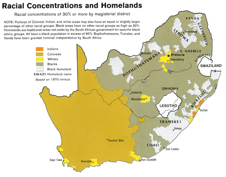
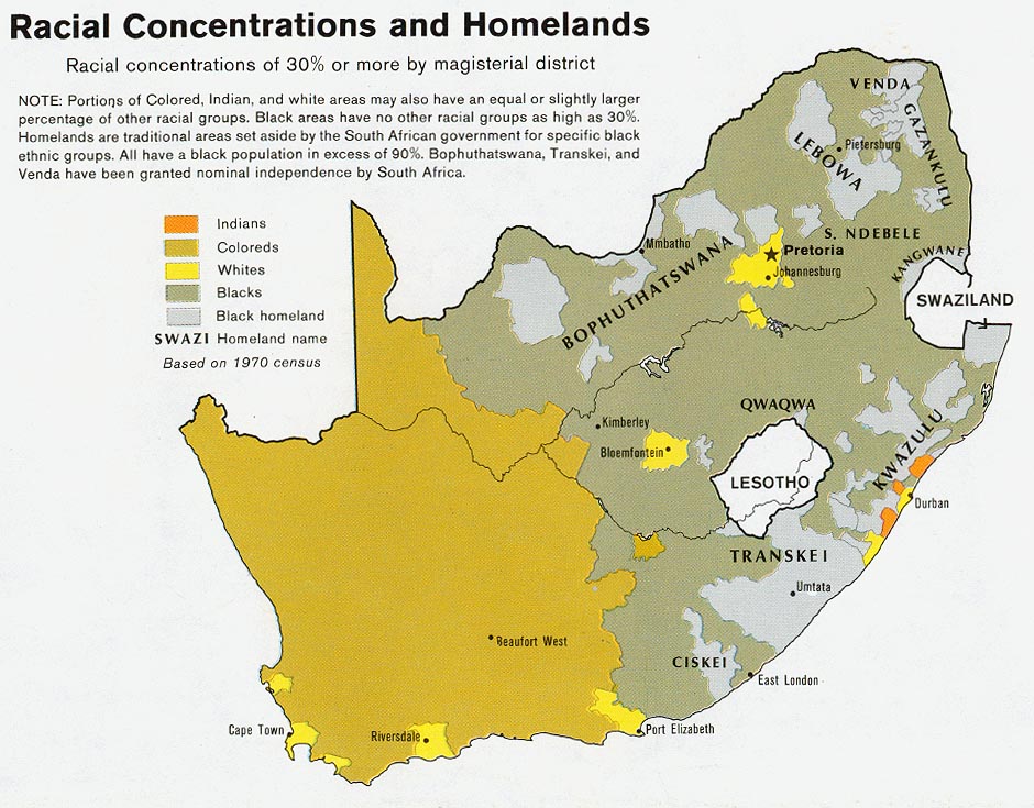
English: Map showing the territorial four main races/ethnicities/colors of South Africa in 1979: Whites, Coloureds, Blacks and Indians. The gray areas indicate the Apartheid-era Bantustans, which are almost exclusively black.
This map is a photoshopped version of the CIA-made original map at Perry Castañeda map collection at the University of Texas website. |
| تاریخ | |
| منبع |
Transferred from en.wikipedia to Commons by Magnus Manske using CommonsHelper. (Original text : * Site: Perry-Castañeda Library Map Collection: South Africa Maps |
| پدیدآور | U.S. Central Intelligence Agency |
| اجازهنامه (استفادهٔ مجدد از این پرونده) |
Public domain |
| دیگر نسخهها |
 |
اجازهنامه
| This image is a work of a Central Intelligence Agency employee, taken or made as part of that person's official duties. As a Work of the United States Government, this image or media is in the public domain in the United States.
|

|
سیاهه بارگذاری اصلی
صفحهٔ اصلی توضیحات اینجابود. همهٔ نامهای کاربر زیر به en.wikipedia اشاره دارند.
- 2008-08-23 06:02 MaGioZal 940×735× (254595 bytes) Map showing the territorial four main races/ethnicities/colors of South Africa in 1979: [[South African Whites|Whites]], [[Colored (South Africa)|Coloreds]], [[South African Blacks|Blacks]] and [[South African Indians|Indians]]. The gray areas indicate th
تاریخچهٔ پرونده
روی تاریخ/زمانها کلیک کنید تا نسخهٔ مربوط به آن هنگام را ببینید.
| تاریخ/زمان | بندانگشتی | ابعاد | کاربر | توضیح | |
|---|---|---|---|---|---|
| کنونی | ۱۹ فوریهٔ ۲۰۱۱، ساعت ۲۰:۵۰ | | ۹۴۰ در ۷۳۵ (۲۴۹ کیلوبایت) | File Upload Bot (Magnus Manske) | {{BotMoveToCommons|en.wikipedia|year={{subst:CURRENTYEAR}}|month={{subst:CURRENTMONTHNAME}}|day={{subst:CURRENTDAY}}}} {{Information |Description={{en|Map showing the territorial four main races/ethnicities/colors of South Africa in 1979: [[:en:Whites in |
کاربرد پرونده
صفحهٔ زیر از این تصویر استفاده میکند:
کاربرد سراسری پرونده
ویکیهای دیگر زیر از این پرونده استفاده میکنند:
- کاربرد در af.wikipedia.org
- کاربرد در ast.wikipedia.org
- کاربرد در ca.wikipedia.org
- کاربرد در cs.wikipedia.org
- کاربرد در en.wikipedia.org
- کاربرد در es.wikipedia.org
- کاربرد در he.wikipedia.org
- کاربرد در krc.wikipedia.org
- کاربرد در pnb.wikipedia.org
- کاربرد در pt.wikipedia.org
- کاربرد در sh.wikipedia.org
- کاربرد در sl.wikipedia.org
- کاربرد در sr.wikipedia.org
- کاربرد در ta.wikipedia.org
- کاربرد در uk.wikipedia.org
- کاربرد در zh.wikipedia.org