
پرونده:Rear map.jpg

پروندهٔ اصلی (۲٬۲۰۱ × ۱٬۶۱۷ پیکسل، اندازهٔ پرونده: ۱٫۶۱ مگابایت، نوع MIME پرونده: image/jpeg)
این پرونده در ویکیانبار موجود است. محتویات صفحهٔ توصیف آن در زیر نمایش داده میشود. |
خلاصه
| توضیح |
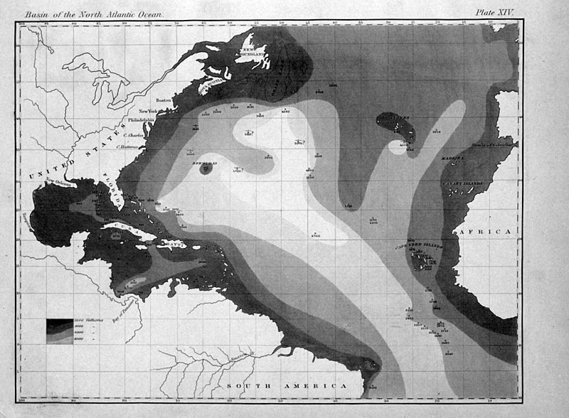
English: "The very earliest rendition of a bathymetric map of an oceanic basin. Matthew Fontaine Maury published this map in 1853 in Explanations and Sailing Directions to Accompany the Wind and Current Charts." |
| تاریخ | |
| منبع |
http://oceanexplorer.noaa.gov/history/readings/vicissitudes/media/gulf.html |
| پدیدآور | Matthew Fontaine Maury |
اجازهنامه
This image is in the public domain because it contains materials that originally came from the U.S. National Oceanic and Atmospheric Administration, taken or made as part of an employee's official duties.
|
|
این اثر در کشورهایی و مناطقی که مدت زمان حق تکثیر، عمر پدیدآورنده بعلاوه 70 سال یا کمتر بعد از مرگ او است، در مالکیت عمومی قرار دارد.
| |
| این پرونده تحت قانون حق تکثیر محدودیت آزاد منتشر شده که شامل تمامی حقوق مربوطه و حقوق نزدیک به آن میشود. | |
تاریخچهٔ پرونده
روی تاریخ/زمانها کلیک کنید تا نسخهٔ مربوط به آن هنگام را ببینید.
| تاریخ/زمان | بندانگشتی | ابعاد | کاربر | توضیح | |
|---|---|---|---|---|---|
| کنونی | ۶ اوت ۲۰۱۱، ساعت ۱۶:۳۱ | | ۲٬۲۰۱ در ۱٬۶۱۷ (۱٫۶۱ مگابایت) | Belg4mit | {{Information |Description ={{en|1="The very earliest rendition of a bathymetric map of an oceanic basin. Matthew Fontaine Maury published this map in 1853 in ''Explanations and Sailing Directions to Accompany the Wind and Current Charts''."}} |Sou |
کاربرد پرونده
صفحهٔ زیر از این تصویر استفاده میکند:
کاربرد سراسری پرونده
ویکیهای دیگر زیر از این پرونده استفاده میکنند:
- کاربرد در bg.wikipedia.org
- کاربرد در en.wikipedia.org
- کاربرد در eo.wikipedia.org
- کاربرد در fr.wikipedia.org
- کاربرد در mk.wikipedia.org
- کاربرد در pt.wikipedia.org
- کاربرد در tr.wikipedia.org
- کاربرد در zh.wikipedia.org