
پرونده:Kingdom of France (1789).svg

حجم پیشنمایش PNG این SVG file:۴۵۰ × ۴۵۶ پیکسل کیفیتهای دیگر: ۲۳۷ × ۲۴۰ پیکسل | ۴۷۴ × ۴۸۰ پیکسل | ۷۵۸ × ۷۶۸ پیکسل | ۱٬۰۱۱ × ۱٬۰۲۴ پیکسل | ۲٬۰۲۱ × ۲٬۰۴۸ پیکسل.
پروندهٔ اصلی (پروندهٔ اسویجی، با ابعاد ۴۵۰ × ۴۵۶ پیکسل، اندازهٔ پرونده: ۹۱۱ کیلوبایت)
این پرونده در ویکیانبار موجود است. محتویات صفحهٔ توصیف آن در زیر نمایش داده میشود. |
خلاصه


.svg)
.svg)
.svg)
.svg)
.svg)


.svg)
.svg)
.svg)


.png)
.png)


.svg)


.svg)

.svg)


.svg)
.svg)
.svg)
.svg)


.svg)
.png)


.svg)


.svg)
.svg)


.svg)


.svg)


.svg?uselang=fa)
.svg)
.svg)
.svg)
.svg)
.svg)
.svg)
.svg)
_cropped.svg)
.svg)
.svg)
.svg)
.svg)
.svg)
.svg)
.svg)
.svg)
.svg)
.svg)
.svg)
.svg)
.svg)
.svg)
.svg)
.svg)
.svg)
.svg)
.svg)
.svg)
.svg)
.svg)
.svg)
.svg)
.svg)
.svg)
.svg)
.svg)
.svg)
.svg)
.svg)
.svg)
.svg)
.svg)
.svg)
.svg)
.svg)
.svg)
.svg)
.svg)
.svg)
.svg)
.svg)
.svg)
.svg)
تاریخچهٔ پرونده
روی تاریخ/زمانها کلیک کنید تا نسخهٔ مربوط به آن هنگام را ببینید.
| تاریخ/زمان | بندانگشتی | ابعاد | کاربر | توضیح | |
|---|---|---|---|---|---|
| کنونی | ۱۷ اکتبر ۲۰۲۱، ساعت ۰۸:۱۲ | | ۴۵۰ در ۴۵۶ (۹۱۱ کیلوبایت) | Fenn-O-maniC | Fixed the Russo-Swedish border to match the Treaty of Åbo of 1743 |
| ۲۹ دسامبر ۲۰۱۷، ساعت ۰۶:۳۶ |  | ۴۵۰ در ۴۵۶ (۹۱۴ کیلوبایت) | TRAJAN 117 | Update | |
| ۲۵ دسامبر ۲۰۱۷، ساعت ۰۱:۵۵ |  | ۴۵۰ در ۴۵۶ (۸۳۲ کیلوبایت) | TRAJAN 117 | +++ | |
| ۲۷ اوت ۲۰۱۳، ساعت ۰۲:۱۴ |  | ۴۵۰ در ۴۵۶ (۸۰۲ کیلوبایت) | TRAJAN 117 | +++ | |
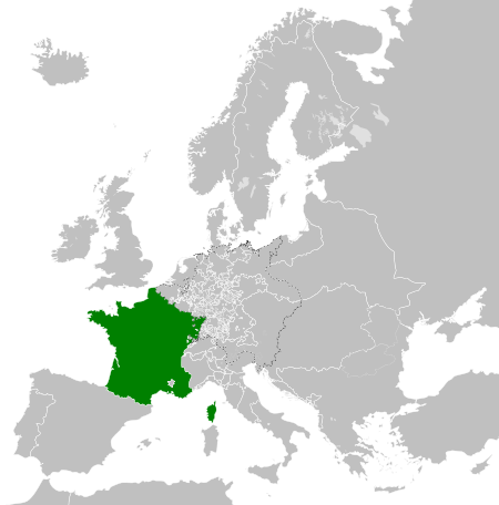
| ۷ مهٔ ۲۰۱۳، ساعت ۲۱:۵۲ |  | ۴۵۰ در ۴۵۶ (۸۳۹ کیلوبایت) | TRAJAN 117 | {{Information |Description ={{en|1=The Kingdom of France in 1789.}} |Source ={{own}} {{AttribSVG|Europe 1789.svg|Alphathon}} |Author =TRAJAN 117 {{created with Inkscape}} |Date =2013-05-07 |Permission ... |
کاربرد پرونده
صفحهٔ زیر از این تصویر استفاده میکند:
کاربرد سراسری پرونده
ویکیهای دیگر زیر از این پرونده استفاده میکنند:
- کاربرد در ar.wikipedia.org
- کاربرد در arz.wikipedia.org
- کاربرد در ast.wikipedia.org
- کاربرد در az.wikipedia.org
- کاربرد در be.wikipedia.org
- کاربرد در bg.wikipedia.org
- کاربرد در cs.wikipedia.org
- کاربرد در da.wikipedia.org
- کاربرد در de.wikipedia.org
- کاربرد در el.wikipedia.org
- کاربرد در en.wikipedia.org
- کاربرد در es.wikipedia.org
- کاربرد در fi.wikipedia.org
- کاربرد در fr.wikipedia.org
- کاربرد در ga.wikipedia.org
- کاربرد در gl.wikipedia.org
- کاربرد در he.wikipedia.org
- کاربرد در hr.wikipedia.org
- کاربرد در hu.wikipedia.org
- کاربرد در id.wikipedia.org
- کاربرد در incubator.wikimedia.org
- کاربرد در is.wikipedia.org
- کاربرد در it.wikipedia.org
- کاربرد در ja.wikipedia.org
- کاربرد در ka.wikipedia.org
- کاربرد در ko.wikipedia.org
- کاربرد در lfn.wikipedia.org
- کاربرد در lmo.wikipedia.org
- کاربرد در lt.wikipedia.org
- کاربرد در lv.wikipedia.org
- کاربرد در ms.wikipedia.org
- کاربرد در no.wikipedia.org
- کاربرد در nrm.wikipedia.org
نمایش استفادههای سراسری از این پرونده.
.svg)
.svg)