
پرونده:Khuriya muriya 76.jpg

تفکیکپذیری بالاتری در دسترس نیست.
Khuriya_muriya_76.jpg (۴۳۶ × ۳۶۰ پیکسل، اندازهٔ پرونده: ۳۱ کیلوبایت، نوع MIME پرونده: image/jpeg)
این پرونده در ویکیانبار موجود است. محتویات صفحهٔ توصیف آن در زیر نمایش داده میشود. |
خلاصه
| توضیح |
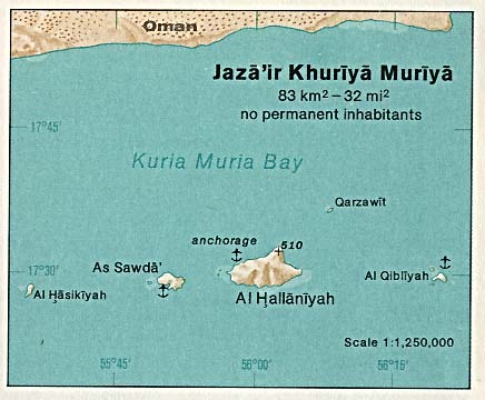
Deutsch: Karte der Kuria-Muria-Inseln (Oman) im Indischen Ozean
English: Map of Khuriya Muriya Islands (Oman) in the Indian Ocean |
| تاریخ | |
| منبع | http://www.lib.utexas.edu/maps/islands_oceans_poles/jaza'ir_khuriya_muriya.jpg |
| پدیدآور | Taken from Perry-Castañeda Library (PCL), originally from CIA Indian Ocean Atlas |
اجازهنامه
| This image is a work of a Central Intelligence Agency employee, taken or made as part of that person's official duties. As a Work of the United States Government, this image or media is in the public domain in the United States.
|

|
تاریخچهٔ پرونده
روی تاریخ/زمانها کلیک کنید تا نسخهٔ مربوط به آن هنگام را ببینید.
| تاریخ/زمان | بندانگشتی | ابعاد | کاربر | توضیح | |
|---|---|---|---|---|---|
| کنونی | ۱۰ ژوئیهٔ ۲۰۰۷، ساعت ۱۱:۵۰ | | ۴۳۶ در ۳۶۰ (۳۱ کیلوبایت) | Telim tor | == Information == {{Information |Description= {{de|Karte der Kuria-Muria-Inseln (Oman) im Indischen Ozean}} {{en|Map of Khuriya Muriya Islands (Oman) in the Indian Ocean}} |Source=http://www.lib.utexas.edu/maps/islands_oceans_poles/jaza'ir_khuriya_muriya. |
کاربرد پرونده
صفحهٔ زیر از این تصویر استفاده میکند:
کاربرد سراسری پرونده
ویکیهای دیگر زیر از این پرونده استفاده میکنند:
- کاربرد در ar.wikipedia.org
- کاربرد در az.wikipedia.org
- کاربرد در be.wikipedia.org
- کاربرد در ca.wikipedia.org
- کاربرد در ceb.wikipedia.org
- کاربرد در cs.wikipedia.org
- کاربرد در de.wikipedia.org
- کاربرد در en.wikipedia.org
- کاربرد در eo.wikipedia.org
- کاربرد در es.wikipedia.org
- کاربرد در fi.wikipedia.org
- کاربرد در fr.wikipedia.org
- کاربرد در it.wikipedia.org
- کاربرد در ja.wikipedia.org
- کاربرد در lt.wikipedia.org
- کاربرد در nl.wikipedia.org
- کاربرد در nn.wikipedia.org
- کاربرد در no.wikipedia.org
- کاربرد در pl.wikipedia.org
- کاربرد در pt.wikipedia.org
- کاربرد در ru.wikipedia.org
- کاربرد در sr.wikipedia.org
- کاربرد در sv.wikipedia.org
- کاربرد در uk.wikipedia.org
- کاربرد در www.wikidata.org
- کاربرد در zh.wikipedia.org