
پرونده:India-Pakistan Border at Night.jpg

پروندهٔ اصلی (۴٬۹۲۸ × ۳٬۲۸۰ پیکسل، اندازهٔ پرونده: ۵٫۳ مگابایت، نوع MIME پرونده: image/jpeg)
این پرونده در ویکیانبار موجود است. محتویات صفحهٔ توصیف آن در زیر نمایش داده میشود. |
خلاصه
| توضیح |
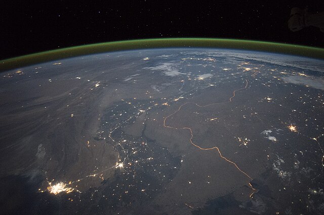
English: An astronaut aboard the International Space Station took this nighttime panorama while looking north across Pakistan’s Indus River valley. The port city of Karachi is the bright cluster of lights facing the Arabian Sea, which appears completely black. City lights and the dark color of dense agriculture closely track with the great curves of the Indus valley. For scale, the distance from Karachi to the foothills of the Himalaya Mountains is 1,160 kilometers (720 miles).
This photograph shows one of the few places on Earth where an international boundary can be seen at night. The winding border between Pakistan and India is lit by security lights that have a distinct orange tone. Another night image (click here) shows the border zone looking southeast from the Himalaya. A daylight view shows the vegetated bends of the Indus Valley winding through the otherwise desert country. More than two millennia ago, Alexander the Great entered the Indus plains in 327 BCE from the northwest. He then spent many months leading his army and navy down the length of the Indus valley shown in this view. From near Karachi, he then began the desert march back to Mesopotamia (modern Iraq). By contrast, it takes the space station just three minutes to travel this distance. |
| تاریخ | ۲۳ سپتامبر ۲۰۱۵, ۱۷:۱۵:۴۸ GMT |
| منبع | NASA Earth Observatory |
| پدیدآور | ISS Expedition 45 crew |
| مختصات دوربین | | محل قرارگیری این نگاره و سایر نگارهها در: نقشهٔ شهری باز |
|---|
این نگاره یا ویدیو توسط مرکز فضایی جانسون سازمان ملی هوانوردی و فضایی (NASA)ایالات متحدهٔ آمریکا تحت شناسهٔ عکس: ISS045-E-27869کاتالوگ شدهاست. این برچست وضعیت حق تکثیر اثر ضمیمه شده را مشخص نمیکند. یک برچسپ معمولی همچنان مورد نیاز است. Commons:Licensing را برای کسب اطلاعات مشاهده فرمایید. زبانهای دیگر:
|
Image acquired with a Nikon D4 digital camera using a 28 millimeter lens, and is provided by the ISS Crew Earth Observations Facility and the Earth Science and Remote Sensing Unit, Johnson Space Center.
اجازهنامه
| این پرونده در مالکیت عمومی قرار دارد چرا که توسط ناسا ایجاد شده است. سیاست حق تکثیر ناسا بیان میکند که «مواد ناسا با حق تکثیر محافظت نمیشوند، مگراینکه ذکر شده باشد». (Template:PD-USGov، صفحهٔ سیاست حق تکثیر ناسا یا سیاست جیپیال استفاده از تصاویر را ببینید.) | ||
 |
هشدارها:
|
تاریخچهٔ پرونده
روی تاریخ/زمانها کلیک کنید تا نسخهٔ مربوط به آن هنگام را ببینید.
| تاریخ/زمان | بندانگشتی | ابعاد | کاربر | توضیح | |
|---|---|---|---|---|---|
| کنونی | ۵ اکتبر ۲۰۱۵، ساعت ۱۹:۰۸ | | ۴٬۹۲۸ در ۳٬۲۸۰ (۵٫۳ مگابایت) | Udonknome | User created page with UploadWizard |
کاربرد پرونده
صفحههای زیر از این تصویر استفاده میکنند:
کاربرد سراسری پرونده
ویکیهای دیگر زیر از این پرونده استفاده میکنند:
- کاربرد در az.wikipedia.org
- کاربرد در bn.wikipedia.org
- کاربرد در ca.wikipedia.org
- کاربرد در de.wikipedia.org
- کاربرد در en.wikipedia.org
- کاربرد در fr.wikipedia.org
- Frontière entre l'Inde et le Pakistan
- Discussion:Frontière entre l'Inde et le Pakistan
- Relations entre l'Inde et le Pakistan
- Utilisateur:GhosterBot/BacASable/Le saviez-vous ?/Archives
- Wikipédia:Le saviez-vous ?/Archives/2023
- Wikipédia:Statistiques des anecdotes de la page d'accueil/Visibilité des anecdotes (2023)
- Discussion:Frontière entre l'Inde et le Pakistan/LSV 22562
- Wikipédia:Statistiques des anecdotes de la page d'accueil/Visibilité des anecdotes (2023)/2023 09
- کاربرد در hif.wikipedia.org
- کاربرد در hi.wikipedia.org
- کاربرد در it.wikipedia.org
- کاربرد در ja.wikipedia.org
- کاربرد در kn.wikipedia.org
- کاربرد در pa.wikipedia.org
- کاربرد در pnb.wikipedia.org
- کاربرد در ru.wikipedia.org
- کاربرد در te.wikipedia.org
- کاربرد در tr.wikipedia.org
- کاربرد در vi.wikipedia.org