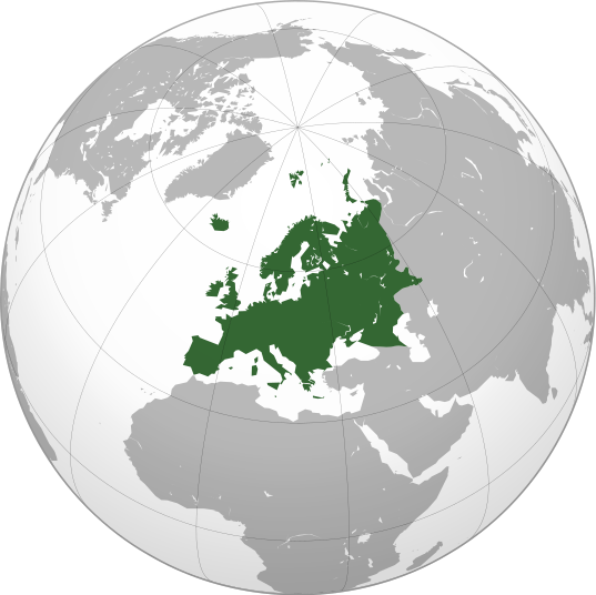
پرونده:Europe orthographic Caucasus Urals boundary.svg

حجم پیشنمایش PNG این SVG file:۵۳۷ × ۵۳۶ پیکسل کیفیتهای دیگر: ۲۴۰ × ۲۴۰ پیکسل | ۴۸۱ × ۴۸۰ پیکسل | ۷۶۹ × ۷۶۸ پیکسل | ۱٬۰۲۶ × ۱٬۰۲۴ پیکسل | ۲٬۰۵۲ × ۲٬۰۴۸ پیکسل.
پروندهٔ اصلی (پروندهٔ اسویجی، با ابعاد ۵۳۷ × ۵۳۶ پیکسل، اندازهٔ پرونده: ۷۷ کیلوبایت)
تاریخچهٔ پرونده
روی تاریخ/زمانها کلیک کنید تا نسخهٔ مربوط به آن هنگام را ببینید.
| تاریخ/زمان | بندانگشتی | ابعاد | کاربر | توضیح | |
|---|---|---|---|---|---|
| کنونی | ۴ سپتامبر ۲۰۲۲، ساعت ۱۳:۳۲ |  | ۵۳۷ در ۵۳۶ (۷۷ کیلوبایت) | M.Bitton | Reverted to version as of 12:03, 4 September 2022 (UTC): per COM:OVERWRITE |
| ۴ سپتامبر ۲۰۲۲، ساعت ۱۳:۳۰ |  | ۵۳۷ در ۵۳۶ (۱۷۷ کیلوبایت) | Рагин1987 | Small correction | |
| ۴ سپتامبر ۲۰۲۲، ساعت ۱۲:۰۳ |  | ۵۳۷ در ۵۳۶ (۷۷ کیلوبایت) | M.Bitton | Reverted to version as of 05:48, 12 March 2019 (UTC): per COM:OVERWRITE + fake svg | |
| ۳۰ اوت ۲۰۲۲، ساعت ۱۹:۱۲ |  | ۲٬۰۵۲ در ۲٬۰۴۸ (۸۷۴ کیلوبایت) | Рагин1987 | More correct visualization of the dividing line on the territory of the Caucasus Range | |
| ۱۲ مارس ۲۰۱۹، ساعت ۰۵:۴۸ |  | ۵۳۷ در ۵۳۶ (۷۷ کیلوبایت) | AndreyKva | Optimized. | |
| ۳ مارس ۲۰۱۶، ساعت ۱۹:۲۵ |  | ۵۳۷ در ۵۳۶ (۱۹۷ کیلوبایت) | Denniss | Reverted to version as of 13:27, 19 October 2014 (UTC) | |
| ۳ مارس ۲۰۱۶، ساعت ۱۸:۳۷ |  | ۵۳۷ در ۵۳۶ (۲۳۹ کیلوبایت) | Ercwlff | UC UC UC | |
| ۱۹ اکتبر ۲۰۱۴، ساعت ۱۳:۲۷ |  | ۵۳۷ در ۵۳۶ (۱۹۷ کیلوبایت) | Deni Mataev | Again, The entirety of Georgia is not in Europe geographically, only North Eastern parts are | |
| ۱۸ اکتبر ۲۰۱۴، ساعت ۲۰:۰۵ |  | ۵۳۷ در ۵۳۶ (۲۳۸ کیلوبایت) | Politologia | Reverted to version as of 10:57, 18 October 2014 In all maps Georgia is part of Georgia. There is at list 10 versions of borders of Europe in most of them Georgia is part of Europa | |
| ۱۸ اکتبر ۲۰۱۴، ساعت ۲۰:۰۴ |  | ۵۳۷ در ۵۳۶ (۲۳۸ کیلوبایت) | Politologia | Reverted to version as of 10:57, 18 October 2014 In all maps Georgia is part of Georgia. |
کاربرد پرونده
صفحههای زیر از این تصویر استفاده میکنند:
کاربرد سراسری پرونده
ویکیهای دیگر زیر از این پرونده استفاده میکنند:
- کاربرد در ab.wikipedia.org
- کاربرد در ace.wikipedia.org
- کاربرد در ady.wikipedia.org
- کاربرد در af.wikipedia.org
- کاربرد در ar.wikipedia.org
- بوابة:آسيا
- بوابة:أوروبا
- بوابة:إفريقيا
- بوابة:القارة القطبية الجنوبية
- بوابة:القارة القطبية الجنوبية/بوابات شقيقة
- قائمة جوازات السفر
- بوابة:تركيا
- بوابة:تركيا/بوابات شقيقة
- بوابة:جغرافيا/مقالة مختارة/أرشيف
- المرأة في تركيا
- بوابة:أوروبا/واجهة
- بوابة:تصفح
- بوابة:تصفح/جغرافيا
- قائمة مفاتيح الاتصال الدولية
- المرأة في ألمانيا
- بوابة:إسطنبول
- بوابة:آسيا/بوابات شقيقة
- ويكيبيديا:مقالة الصفحة الرئيسية المختارة/398
- بوابة:جغرافيا/مقالة مختارة/21
- معاملة المثليين في أوروبا
- المرأة في أوروبا
- المرأة في البرتغال
- المرأة في فنلندا
- المرأة في مقدونيا الشمالية
- المرأة في ترانسنيستريا
- المرأة في الفاتيكان
- المرأة في أذربيجان
- المرأة في اليونان
- المرأة في ألبانيا
- المرأة في إيطاليا
- المرأة في الجبل الأسود
نمایش استفادههای سراسری از این پرونده.


