
پرونده:Europe in 1923.jpg

پروندهٔ اصلی (۷٬۰۹۷ × ۵٬۴۵۶ پیکسل، اندازهٔ پرونده: ۶٫۹۷ مگابایت، نوع MIME پرونده: image/jpeg)
این پرونده در ویکیانبار موجود است. محتویات صفحهٔ توصیف آن در زیر نمایش داده میشود. |
خلاصه
| Description |
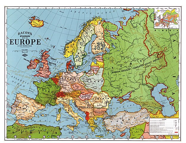
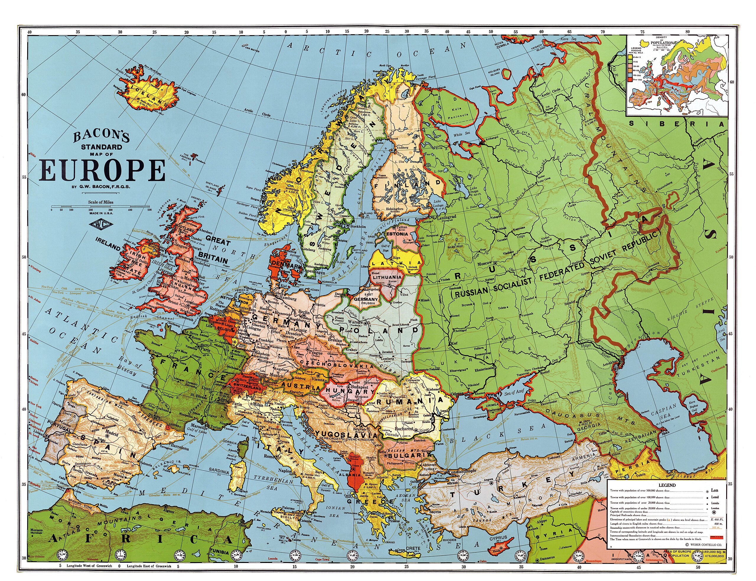
English: Bacon's standard map of Europe, 1923. Relief shown by hachures and spot heights. Shows steamship routes and time zones. Published by Weber Costello Co., 84 x 111 cm. Scale 1:5,500,000 (W 52°--E 80°/N 60°--N 30°).
Français : Carte "standard" de l'Europe au 1/5 500 000, par Bacon, 1923. Les reliefs sont donnés par des hachures et des indications de certaines altitudes. Les principales routes maritimes sont indiquées, ainsi que les fuseaŭx horaires. Publié par la compagnie Weber Costello, 84 x 111 cm.
Italiano: Carta geografica generale dell'Europa in lingua inglese (84 x 111 cm, scala 1:5 500 000), realizzata da G. W. Bacon e pubblicata da Weber Costello Co. nel 1923
Polski: Mapa Europy w skali 1:5500000 wydawnictwa Weber Costello Co. Uwzględnia granice z 1923 r. oraz m.in. szlaki morskie i strefy czasowe.
Türkçe: 1923 yılındaki ülke sınırlarını gösteren Avrupa haritası. Yükseltiler tarama çizgiler ve belli noktaların yükseklikleri ile belli edilmiştir. Saat dilimleri ve gemi yolları da gösterilmiştir. |
||
| تاریخ | پس از ۱۹۲۴ | ||
| منبع |
|
||
| پدیدآورنده |
Bacon, George Washington (1830-1921) |
||
| Georeferencing | If inappropriate please set warp_status = skip to hide. | ||
| دیگر نسخهها |


| این یک عکس دستکاری شده است به این معنی که به صورت دیجیتالی از نسخهٔ اصلی تغییر یافتهاست. تغییرها: Contrast enhanced, colors corrected, halves united. تغییرها توسط Alex:D انجام شدهاست. اصل آن میتوان در اینجا یافت شود.
|
|

This image was selected as picture of the day on Wikimedia Commons for 27 May 2010. It was captioned as follows: English: George Washington Bacon's standard map of Europe, 1923. Relief shown by hachures and spot heights. Shows steamship routes and time zones. Published by Weber Costello Co., 84 × 111 cm. Scale 1:5,500,000 (W 52°--E 80°/N 60°--N 30°). Other languages:
Čeština: Standardní mapa Evropy od George Washingtona Bacona z roku 1923; reliéf je značen šrafurou a kótami, vyznačeny jsou tratě parníků a časová pásma; měřítko 1 : 5 500 000, 84 × 111 cm Dansk: George Washington Bacons standardkort over Europa fra 1923. Topografien er vist med skraveringer, og punkter viser bjergtoppe. Kortet viser også skibsruter og tidszoner. Udgivet af Weber Costello Co, 88 × 111 cm. Målestok 1:5.500.000 (52°V - 80°Ø / 60°N - 30°N). Deutsch: George Washington Bacons Standardkarte von Europa von 1923. Die Topografie wird durch Schraffuren und Punkthöhen dargestellt. Ebenso sind Dampferrouten und Zeitzonen dargestellt. Veröffentlicht durch Weber Costello Co., 84 × 111 cm. Maßstab 1:5,500,000 (W 52°--E 80°/N 60°--N 30°). English: George Washington Bacon's standard map of Europe, 1923. Relief shown by hachures and spot heights. Shows steamship routes and time zones. Published by Weber Costello Co., 84 × 111 cm. Scale 1:5,500,000 (W 52°--E 80°/N 60°--N 30°). Español: Mapa estándar de Europa de George Washington Bacon, 1923. El relieve se muestra con líneas de sombra y puntos de altura. Incluye rutas de barcos a vapor y zonas horarias. Publicado por Weber Costello Co., 84×111 cm. Escala 1:5.500.000 (52° O–80° E/60° N–30° N). Français : Carte "standard" de l'Europe au 1/5 500 000, par Bacon, 1923. Les reliefs sont donnés par des hachures et des indications de certaines altitudes. Les principales routes maritimes sont indiquées, ainsi que les fuseaux horaires. Publié par la compagnie Weber Costello, 84 x 111 cm. Italiano: Carta geografica generale dell'Europa in lingua inglese (84 x 111 cm, scala 1:5 500 000), realizzata da G. W. Bacon e pubblicata da Weber Costello Co. nel 1923 Magyar: Európa-térkép 1923-ból, időzónákkal és hajóutakkal Nederlands: Standaardkaart van Europa uit 1923 van de Britse uitgever George Washington Bacon (1830-1922). De topografie wordt weergegeven door arceringen en hoogtepunten. Ook zijn stoombootroutes en tijdzones afgebeeld. Uitgegeven door Weber Costello Co. Afmeting: 84 × 111 cm. Schaal 1:5.500.000 (W 52° - E 80°/N 60° - N 30°). Português: Mapa da Europa publicado em 1923. Беларуская (тарашкевіца): Агульная мапа Эўропы Джорджа Вашынгтона Бэкана 1923 году. Выдадзена Weber Costello Co., 84 × 111 см. Маштаб 1:5 500 000 (З 52°—У 80°/П 60°—П 30°). Македонски: Бејконова стандардна карта на Европа на (1923). Релјефот е изразен со сенчање и коти. Прикажани се парабродски маршрути и часовни зони. Издавач: Weber Costello Co., 84 × 111 cm. Размер: 1:5.500.000 (З 52°--И 80°/С 60°--С 30°). Українська: Карта Європи 1923 року англійського видавця книг і мап Джорджа Вашінгтона Бейкена. Зображено рельєф, пароплавні маршрути, часові пояси. Надруковано Weber Costello Co., 84 × 111 см. Масштаб 1:5 500 000 (З 52°— С 80°/П 60° — П 30°). বাংলা : ১৯২৩ সালে জর্জ ওয়াশিংটন বেকন কর্তৃক অঙ্কিত ইউরোপের মানচিত্র। কোনো স্থানের উচ্চতা প্রদর্শিত হয়েছে, সেই সাথে বাষ্পীয় ইঞ্জিন চালিত জাহাজের চলাচলের পথ ও সময়স্থানও সূচিত হয়েছে। এটি প্রকাশ করেছিলো ওয়েবার ক্যাসটেল্লো কোম্পানি। প্রকাশের সময় এর আকৃতি ছিলো ৮৪ × ১১১ সেন্টিমিটার। স্কেল ১:৫,৫০০,০০০ (প্রদর্শিত স্থান: ৫২° পশ্চিম - ৮০° পূর্ব ও ৬০° উত্তর থেকে ৩০° উত্তর)। 한국어: 1923년의 유럽 지도. 日本語: 「ベーコンの標準ヨーロッパ地図」縮尺 1 : 5,500,000。1923年アメリカ製。 中文: 1923年版本的欧洲地图,比例尺为1:5,500,000,尺寸为84 x 111 cm 中文(繁體): 1923年版本的歐洲地圖,比例尺為1:5,500,000,尺寸為84 x 111 cm。 |
اجازهنامه
|
این اثر در کشورهایی و مناطقی که مدت زمان حق تکثیر، عمر پدیدآورنده بعلاوه 70 سال یا کمتر بعد از مرگ او است، در مالکیت عمومی قرار دارد.
| |
| این پرونده تحت قانون حق تکثیر محدودیت آزاد منتشر شده که شامل تمامی حقوق مربوطه و حقوق نزدیک به آن میشود. | |
این پروندهٔ رسانهای در ایالات متحده در مالکیت عمومی قرار دارد. این دربارهٔ آثار ایالات متحده که حقتکثیرشان باطل شده است صدق میکند؛ اغلب به این دلیل که اولین انتشارشان قبل از ۱ ژانویهٔ ۱۹۲۹ روی داده است. برای توضیحات بیشتر این صفحه را ببینید.
|
 | |
 |
ممکن است این نگاره در خارج از ایالات متحده در مالکیت عمومی نباشد؛ این مسئله بهخصوص دربارهٔ کشورها و مناطقی که قانون مدت کوتاهتر را برای آثار ایالات متحدهٔ آمریکا اعمال نمیکنند، همچون کانادا، چین (به جز هنگکنگ و ماکائو)، آلمان، مکیزیک، و سوئیس صدق میکند. آفریننده و سال انتشار اطلاعات ضروری هستند و باید ارائه شوند. برای جزئیات بیشتر، ویکیپدیا:مالکیت عمومی و ویکیپدیا:حق تکثیر را ببینید.
|
_en.png)
.png)
.jpg)
تاریخچهٔ پرونده
روی تاریخ/زمانها کلیک کنید تا نسخهٔ مربوط به آن هنگام را ببینید.
| تاریخ/زمان | بندانگشتی | ابعاد | کاربر | توضیح | |
|---|---|---|---|---|---|
| کنونی | ۲۵ ژانویهٔ ۲۰۱۳، ساعت ۱۴:۱۵ | | ۷٬۰۹۷ در ۵٬۴۵۶ (۶٫۹۷ مگابایت) | Slick-o-bot | Bot: convert to a non-interlaced jpeg (see bug #17645) |
| ۱ مهٔ ۲۰۰۹، ساعت ۰۶:۵۸ |  | ۷٬۰۹۷ در ۵٬۴۵۶ (۶٫۵۴ مگابایت) | Alex:D | {{Information |Description= {{en|Bacon's standard map of Europe, 1923. Published by Weber Costello Co., 84 x 111 cm. Relief shown by hachures and spot heights. Shows steamship routes and time zones. Scale 1:5,500,000 (W 52°--E 80°/N 60°--N 30°).} |
کاربرد پرونده
صفحهٔ زیر از این تصویر استفاده میکند:
کاربرد سراسری پرونده
ویکیهای دیگر زیر از این پرونده استفاده میکنند:
- کاربرد در af.wikipedia.org
- کاربرد در ar.wikipedia.org
- کاربرد در ast.wikipedia.org
- کاربرد در ba.wikipedia.org
- کاربرد در bg.wikipedia.org
- کاربرد در bn.wikipedia.org
- کاربرد در bs.wikipedia.org
- کاربرد در crh.wikipedia.org
- کاربرد در cs.wikipedia.org
- کاربرد در cv.wikipedia.org
- کاربرد در cy.wikipedia.org
- کاربرد در da.wikipedia.org
- کاربرد در de.wikipedia.org
- کاربرد در en.wikipedia.org
- Russian Civil War
- Treaty of Brest-Litovsk
- Interwar period
- User talk:Alex:D
- Wikipedia:Featured pictures/Diagrams, drawings, and maps/Maps
- Wikipedia:WikiProject Military history/Showcase
- Wikipedia:WikiProject Military history/Showcase/FP
- Wikipedia:Graphics Lab/Map workshop/Archive/Jan 2010
- User:Kazkaskazkasako/Books/History
- Revolutions of 1917–1923
- User:Dtale1984
- 1937 tour of Germany by the Duke and Duchess of Windsor
- Wikipedia:WikiProject Women in Red/Meetup/135
- User:Falcaorib
- User:RJMwikiboy/sandbox
- Wikipedia:Featured pictures thumbs/67
- User:Ssss2323/sandbox
- Wikipedia:Featured picture candidates/June-2020
- Wikipedia:Featured picture candidates/A map of interwar Europe, 1923
- Wikipedia:Wikipedia Signpost/2020-06-28/Featured content
- Wikipedia:Wikipedia Signpost/Single/2020-06-28
- Portal:History/Recognized content
- Wikipedia:Picture of the day/May 2022
- Template:POTD/2022-05-09
- Wikipedia:Main Page history/2022 May 9
- Wikipedia:Main Page history/2022 May 9b
- User talk:TheFreeWorld/Archive 1
- کاربرد در en.wikibooks.org
- کاربرد در eo.wikiquote.org
- کاربرد در es.wikipedia.org
- کاربرد در es.wikibooks.org
- کاربرد در et.wikipedia.org
نمایش استفادههای سراسری از این پرونده.