
پرونده:Cantinomap redsea persiangulf.jpg

پروندهٔ اصلی (۶۶۶ × ۶۰۵ پیکسل، اندازهٔ پرونده: ۳۱۸ کیلوبایت، نوع MIME پرونده: image/jpeg)
این پرونده در ویکیانبار موجود است. محتویات صفحهٔ توصیف آن در زیر نمایش داده میشود. |
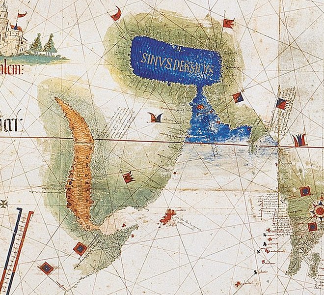
| توضیح | Enlarged detail showing Red Sea and Persian Gulf as viewed in 1502 in the Cantino World Map. Most important manuscript map surviving from the early Age of Discovery, the Cantino World Map is named for Alberto Cantino, an Italian diplomatic agent in Lisbon who obtained it in 1502 for the Duke of Ferrara. It incorporates extensive new geographical information based on four series of voyages: Columbus to the Caribbean, Pedro Álvarez Cabral to Brazil, Vasco de Gama followed by Cabral to eastern Africa and India, and the brothers Corte-Real to Greenland and Newfoundland. Except for Columbus, all had sailed under the Portuguese flag. |
| تاریخ | (UTC) |
| منبع | |
| پدیدآور |
|
| این یک عکس دستکاری شده است به این معنی که به صورت دیجیتالی از نسخهٔ اصلی تغییر یافتهاست. تغییرها: zoom in of Cantino map: the Red sea and Persian Golf. اصل آن را میتوان در اینجا مشاهده کرد: CantinoPlanisphere.png.
|
|
این اثر هنری دوبعدی که در این نگاره دیده میشود بخاطر تاریخ درگذشت پدیدآورنده آن یا تاریخ انتشارش هماکنون در سراسر جهان در مالکیت عمومی قرار دارد و استفاده از آن آزاد است.
بنابراین تکثیر آن در ایالات متحده آمریکا، آلمان و بسیاری کشورهای دیگر آزاد است.
| ||||
سیاهه بارگذاری اصلی
This image is a derivative work of the following images:
- File:CantinoPlanisphere.png licensed with PD-Art, PD-old
- 2007-07-01T05:35:29Z Tdmthomas 3528x1656 (12458523 Bytes) {{Information |Description=The most important manuscript map surviving from the early Age of Discovery, the Cantino World Map is named for Alberto Cantino, an Italian diplomatic agent in Lisbon who obtained it in 1502 for the
Uploaded with derivativeFX
تاریخچهٔ پرونده
روی تاریخ/زمانها کلیک کنید تا نسخهٔ مربوط به آن هنگام را ببینید.
| تاریخ/زمان | بندانگشتی | ابعاد | کاربر | توضیح | |
|---|---|---|---|---|---|
| کنونی | ۱۲ دسامبر ۲۰۰۹، ساعت ۱۳:۳۹ | | ۶۶۶ در ۶۰۵ (۳۱۸ کیلوبایت) | Uxbona | {{Information |Description= Enlarged detail showing Red Sea and Persian Gulf as viewed in 1502 in the Cantino World Map. Most important manuscript map surviving from the early Age of Discovery, the Cantino World Map is named for Alberto Cantino, an Italia |
کاربرد پرونده
صفحههای زیر از این تصویر استفاده میکنند:
کاربرد سراسری پرونده
ویکیهای دیگر زیر از این پرونده استفاده میکنند:
- کاربرد در ar.wikipedia.org
- کاربرد در ca.wikipedia.org
- کاربرد در ckb.wikipedia.org
- کاربرد در de.wikipedia.org
- کاربرد در el.wikipedia.org
- کاربرد در en.wikipedia.org
- کاربرد در es.wikipedia.org
- کاربرد در fr.wikipedia.org
- کاربرد در it.wikipedia.org
- کاربرد در mk.wikipedia.org
- کاربرد در ms.wikipedia.org
- کاربرد در pt.wikipedia.org
- کاربرد در ru.wikipedia.org
- کاربرد در uk.wikipedia.org
- کاربرد در yi.wikipedia.org