
پرونده:COVID-19 Prevalence in California by county.svg

پروندهٔ اصلی (پروندهٔ اسویجی، با ابعاد ۳۳۸ × ۴۰۰ پیکسل، اندازهٔ پرونده: ۷۴ کیلوبایت)
این پرونده در ویکیانبار موجود است. محتویات صفحهٔ توصیف آن در زیر نمایش داده میشود. |
خلاصه
| توضیح |
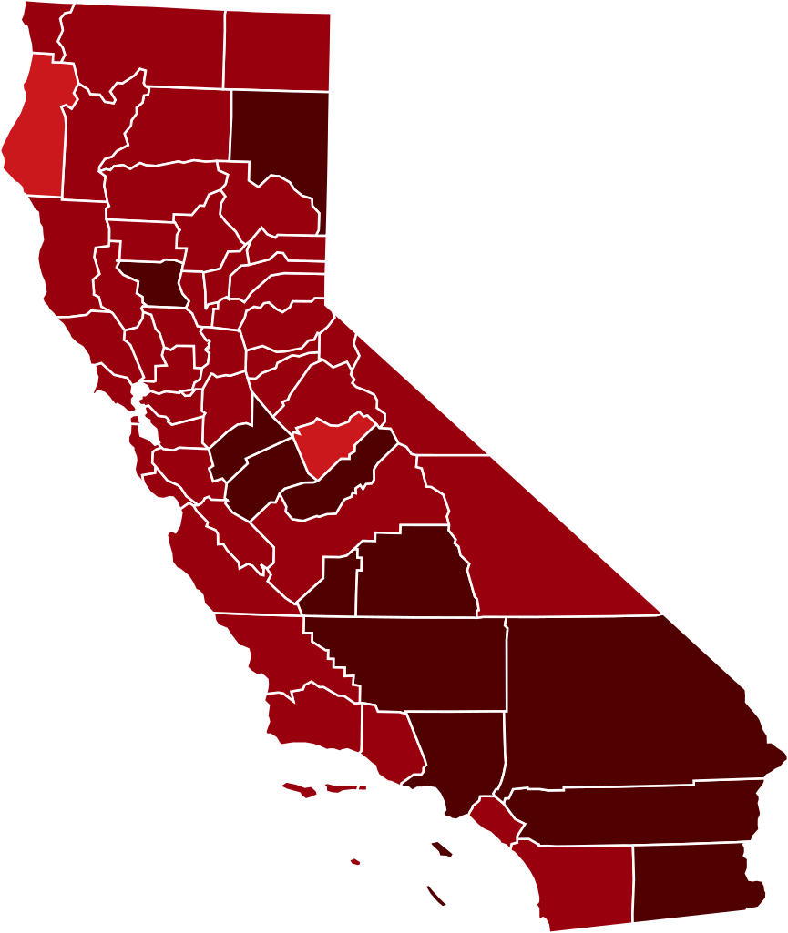
This map shows confirmed cases of w:en:COVID-19, coded by percentage of population confirmed to be infected as of 29 March 2021. The data is used from the data as aggregated and released by Johns Hopkins University and US census (2019 population estimate). As this is a current outbreak, the map might not be up to date. 10.00%+ Confirmed infected
3.00%-10.00% Confirmed infected
1.00%-3.00% Confirmed infected
0.30%-1.00% Confirmed infected
0.10%-0.30% Confirmed infected
0.03%-0.10% Confirmed infected
0.00%-0.03% Confirmed infected
no confirmed cases or no data
The design is based on blank maps available in Public Domain (created by Yiling Chen from TIGER shapefiles), the color scheme is based on color brewer. The script for creating the maps was written by Sukolsak Sakshuwong and Lodewijk Gelauff.
|
||||
| تاریخ | |||||
| منبع | Based on File:Blank_California_Map.svg by user:Thadius856 | ||||
| پدیدآور | The design is based on blank maps available in Public Domain, the color scheme is based on the design created by platypeanArchcow (PD). The script for creating the maps was written by Sukolsak Sakshuwong and Lodewijk Gelauff. |

اجازهنامه
| من، دارنده حق تکثیر این اثر، این اثر را به مالکیت عمومی منتشر میکنم. این قابل اجرا در تمام نقاط جهان است. در برخی از کشورها ممکن است به صورت قانونی این امکانپذیر نباشد؛ اگر چنین است: من اجازهٔ استفاده از این اثر را برای هر مقصودی، بدون هیچگونه شرایطی میدهم، تا وقتی که این شرایط توسط قانون مستلزم نشده باشد. |
تاریخچهٔ پرونده
روی تاریخ/زمانها کلیک کنید تا نسخهٔ مربوط به آن هنگام را ببینید.
| تاریخ/زمان | بندانگشتی | ابعاد | کاربر | توضیح | |
|---|---|---|---|---|---|
| کنونی | ۱۴ مارس ۲۰۲۱، ساعت ۰۶:۱۷ | | ۳۳۸ در ۴۰۰ (۷۴ کیلوبایت) | Eiabot | new data: 13 March 2021 |
| ۲ مارس ۲۰۲۱، ساعت ۰۷:۵۹ |  | ۳۳۸ در ۴۰۰ (۷۴ کیلوبایت) | Eiabot | new data: 01 March 2021 | |
| ۲۱ فوریهٔ ۲۰۲۱، ساعت ۰۶:۲۳ |  | ۳۳۸ در ۴۰۰ (۷۴ کیلوبایت) | Eiabot | new data: 20 February 2021 | |
| ۱۸ فوریهٔ ۲۰۲۱، ساعت ۰۶:۵۸ |  | ۳۳۸ در ۴۰۰ (۷۴ کیلوبایت) | Eiabot | new data: 17 February 2021 | |
| ۱۴ فوریهٔ ۲۰۲۱، ساعت ۰۷:۰۰ |  | ۳۳۸ در ۴۰۰ (۷۴ کیلوبایت) | Eiabot | new data: 13 February 2021 | |
| ۲۷ ژانویهٔ ۲۰۲۱، ساعت ۰۶:۳۲ |  | ۳۳۸ در ۴۰۰ (۷۴ کیلوبایت) | Eiabot | new data: 26 January 2021 | |
| ۲۶ ژانویهٔ ۲۰۲۱، ساعت ۰۷:۵۸ |  | ۳۳۸ در ۴۰۰ (۷۴ کیلوبایت) | Eiabot | new data: 25 January 2021 | |
| ۲۰ ژانویهٔ ۲۰۲۱، ساعت ۰۶:۵۲ |  | ۳۳۸ در ۴۰۰ (۷۴ کیلوبایت) | Eiabot | new data: 19 January 2020 | |
| ۱۷ ژانویهٔ ۲۰۲۱، ساعت ۰۶:۴۳ |  | ۳۳۸ در ۴۰۰ (۷۴ کیلوبایت) | Eiabot | new data: 16 January 2020 | |
| ۱۶ ژانویهٔ ۲۰۲۱، ساعت ۰۶:۱۶ |  | ۳۳۸ در ۴۰۰ (۷۴ کیلوبایت) | Eiabot | new data: 15 January 2020 |
کاربرد پرونده
صفحهٔ زیر از این تصویر استفاده میکند:
کاربرد سراسری پرونده
ویکیهای دیگر زیر از این پرونده استفاده میکنند:
- کاربرد در ar.wikipedia.org
- کاربرد در en.wikipedia.org
- کاربرد در es.wikipedia.org
- کاربرد در id.wikipedia.org
- کاربرد در it.wikipedia.org
- کاربرد در zh.wikipedia.org