پرش به محتوا

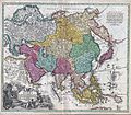
پرونده:1730 C. Homann Map of Asia - Geographicus - Asiae-homann-1730.jpg

Page contents not supported in other languages.
از ویکی‌پدیا، دانشنامهٔ آزاد

پروندهٔ اصلی(۴٬۰۰۰ × ۳٬۴۹۲ پیکسل، اندازهٔ پرونده: ۵٫۲۶ مگابایت، نوع MIME پرونده: image/jpeg)

خلاصه

Johann Christoph Homann: Recentissima Asiae Delineatio : Qua Imperia, eius Regna, et Status, Unacum novissimis Russorum detectionibus circa Mare Caspium et Terram Yedso alias dict. per illor. Expedit. et Excursiones, factis sistuntur.   (Wikidata search (Cirrus search) Wikidata query (SPARQL)  Create new Wikidata item based on this file)
هنرمند
Johann Christoph Homann  (1703–1730)  wikidata:Q18508380
 
توضیحات پزشک، ناشر و نقشه‌کش آلمانی
تاریخ تولد/درگذشت ۱۷۰۳ ویرایش در ویکی‌داده ۱۷۳۰ ویرایش در ویکی‌داده
محل تولد/مرگ نورنبرگ نورنبرگ
محل کار
کنترل از طریق مرجع
artist QS:P170,Q18508380
عنوان
Recentissima Asiae Delineatio : Qua Imperia, eius Regna, et Status, Unacum novissimis Russorum detectionibus circa Mare Caspium et Terram Yedso alias dict. per illor. Expedit. et Excursiones, factis sistuntur.
توضیح
English: A rare and attractive 18th century map of Asia by German map publisher Johann Christoph Homann. Covers the entire continent of Asia as well as parts of Europe and northeastern Africa. This is essentially a revised and updated version of J. B. Homann’s 1712 map of Asia. Features some interesting and important updates. Most notably, we see the addition of the Kamchatka Peninsula in the upper right hand quadrant. The lower part of the peninsula is labeled “Kurilorum Regio”, no doubt an early reference to the Kuril Islands. While Hokkaido is not present, Japan itself is separated from the mainland by a small archipelago. Just east of these islands we see the Canal de Piecko, and beyond that a large and curious land mass labeled Compagnie Land. Compagnie Land is a mythical landmass that can be traced the work of an unknown Spanish pilot who supposedly traveled from China to New Span and published his finding along with the works of Thevenot. Present in both the 1712 map and this one, Compagnie’s Land could possibly be an early representation of Alaska or a misrepresentation of Hokkaido. Korea or Corea is present if misshapen in roughly the correct location. Further south New Guinea, New Britannia, Australia (New Holland), Hoch Land, and Carpentaria (part of Australia) are personated in tentative form with largely unexplored boundaries. At the center of the map the Caspian Sea is displayed according to the 1722 surveys of Karl van Verden. Bottom left quadrant features a decorative title cartouche displaying an enthroned king in Middle Eastern or Indian garb, exotic animals including a lion and leopard, trade goods, Camels, and bowing supplicants. A spectacular and important 18th century map of Asia.
تاریخ حوالی ۱۷۳۰
date QS:P571,+1730-00-00T00:00:00Z/9,P1480,Q5727902
(undated)
ابعاد بلندی: ۱۹٫۵ اینچ (۴۹٫۵ سانتی‌متر)؛ عرض: ۲۲٫۵ اینچ (۵۷٫۱ سانتی‌متر)
dimensions QS:P2048,19.5U218593
dimensions QS:P2049,22.5U218593
آی‌دی
Geographicus link: Asiae-homann-1730
منبع/عکاس
اجازه‌نامه
(استفادهٔ مجدد از این پرونده)
این اثر هنری دوبعدی که در این نگاره دیده می‌شود بخاطر تاریخ درگذشت پدیدآورنده آن یا تاریخ انتشارش هم‌اکنون در سراسر جهان در مالکیت عمومی قرار دارد و استفاده از آن آزاد است.
Public domain

این اثر در کشورهایی و مناطقی که مدت زمان حق تکثیر، عمر پدیدآورنده بعلاوه 100 سال یا کمتر بعد از مرگ او است، در مالکیت عمومی قرار دارد.


You must also include a United States public domain tag to indicate why this work is in the public domain in the United States.
بنابراین تکثیر آن در ایالات متحده آمریکا، آلمان و بسیاری کشورهای دیگر آزاد است.

عنوان

شرحی یک‌خطی از محتوای این فایل اضافه کنید
A rare and attractive 18th century map of Asia by German map publisher Johann Christoph Homann.

آیتم‌هایی که در این پرونده نمایش داده شده‌اند

توصیف‌ها

checksum انگلیسی

50d7f41d7c194c9d50a804aaa1b6cba16d8c371b

۵٬۵۱۶٬۲۱۷ بایت

۳٬۴۹۲ پیکسل

۴٬۰۰۰ پیکسل

تاریخچهٔ پرونده

روی تاریخ/زمان‌ها کلیک کنید تا نسخهٔ مربوط به آن هنگام را ببینید.

تاریخ/زمانبندانگشتیابعادکاربرتوضیح
کنونی‏۱۶ مارس ۲۰۱۱، ساعت ۱۶:۳۵تصویر بندانگشتی از نسخهٔ مورخ ‏۱۶ مارس ۲۰۱۱، ساعت ۱۶:۳۵۴٬۰۰۰ در ۳٬۴۹۲ (۵٫۲۶ مگابایت)BotMultichill{{subst:User:Multichill/Geographicus |link=http://www.geographicus.com/P/AntiqueMap/Asiae-homann-1730 |product_name=1730 C. Homann Map of Asia |map_title=Recentissima Asiae Delineatio : Qua Imperia, eius Regna, et Status, Unacum novissimis Russorum detect

صفحهٔ زیر از این تصویر استفاده می‌کند:

کاربرد سراسری پرونده

ویکی‌های دیگر زیر از این پرونده استفاده می‌کنند: